 As
you head downstream toward the Sabine Street bridge, you will notice a
tributary entering the bayou on the south bank near the street where
Allen Parkway Village ends. This is the outlet of the Crosby Street
storm sewer. This sewer drains rain water and runoff from a large part
of the Fourth Ward and the Montrose area. The significantly large
outlet tunnel attests to that capacity.
As
you head downstream toward the Sabine Street bridge, you will notice a
tributary entering the bayou on the south bank near the street where
Allen Parkway Village ends. This is the outlet of the Crosby Street
storm sewer. This sewer drains rain water and runoff from a large part
of the Fourth Ward and the Montrose area. The significantly large
outlet tunnel attests to that capacity.In periods of low water in the bayou, the stone plaza that has been constructed at the base of the outlet provides a pleasant arena to watch the birds and turtles that inhabit that tree lined tributary. A staircase descends from the sidewalk on Allen Parkway to platforms on the lower level. The circular arrangement of the granite slabs dam the outflow to create a pool while allowing the overflow to drain down the short tributary to its confluence with Buffalo Bayou some two hundred feet away.
Crosby Street is also the western boundary of the Hopson Addition, a subdivision established in 1860 by Mrs. Sarah Ann Hopson. The subdivision was one of five along the San Felipe Road, now West Dallas Avenue, that became the neighborhood where many African-Americans settled after emancipation in 1865. In the early days of Houston, and prior to the Civil War, this part of town had a much different history than that of the post war period of which we are most familiar.
The most notable early settler in the area was John Woodruff. Woodruff had been a farmer and stock raiser in Fort Bend County prior to 1836. John Woodruff served in the Texas Army in the fall of 1835, and with the approach of Santa Ana's army in April, 1836, the Woodruff's abandoned their farm and fled east in the Runaway Scrape, hiding in the timberlands near Clear Creek at the time of the battle at San Jacinto. In December, 1836, Woodruff moved his family to the new town of Houston, settling on land southwest of the town. Woodruff established his farm on fifty acres of land that today extends along the south side of West Dallas Avenue from near Clay Street on the east to Genesee Street on the west.
John Woodruff opened his home on the San Felipe Road as a boarding house, and among his boarders were some of the most influential members of the government of the Republic, including General Edward Burleson, Anson Jones, William Harris Wharton, and William Fairfax Gray, Clerk of the Senate. Woodruff's good connections served him well as he won contracts with the Republic to supply beef and other meats under contract for the Military Hospital in Houston and other governmental units. By 1838, his slaughterhouse and cattle operations were highly successful. However, when the capital of the Republic was moved to Austin in 1840, Woodruff transferred his stock raising operations to the new capital as well.
Woodruff sold his fifty acre farm to Robert C. Campbell in 1840. Campbell sold the fifty acres to Justin Castanie on July 3, 1846. Castanie platted this tract into the Castanie Subdivision on April 12, 1848, and the area had a scattering of residential structures prior to the Civil War.
Other entrepreneurs recognized the livestock potential in the prairies south of the bayou. In the early 1840's, Clement R. Hopson began acquiring property on the north side of the San Felipe Road near the former Woodruff tract. Hopson and his partner John J. Cain established a "tallow factory" or slaughterhouse on the banks of Buffalo Bayou by 1846. In 1850, however, Hopson moved his operations to the new town of Corpus Christi. In a partnership with Corpus Christi founder Henry Kinney, Hopson operated a beef packing company in what is now downtown Corpus Christi during the 1850's. This led to the sale of a portion of his land on the San Felipe Road to Garrett Hardcastle in May 6, 1857. In 1860, Mrs. Sarah Ann Hopson subdivided the Hopson tract on the south bank of Buffalo Bayou into the Hopson Addition. These residential developments set the stage for the post-Civil War growth of the African-American community in this part of the Fourth Ward and the rise of Freedmenstown in Garrett Hardcastle's subdivision.
During the late nineteenth and early twentieth centuries, the businesses of local African-Americans concentrated in the area to the east of Hopson's Addition. This commercial district formed in the vicinity of the Antioch Baptist Church, one of the spiritual centers of the community. By 1926, the Houston Negro Chamber of Commerce was housed in the Pilgrim Temple Building at 222 West Dallas Avenue at Bagby Street. Designed by noted architect Alfred Finn, this building was the focal point of the black business community for over forty years.
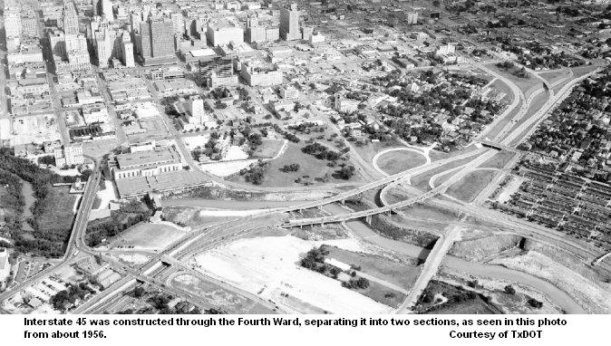 Plans
for Houston's freeway systems were formulated in early 1954, and
by August of that year, the right of way for Interstate 45, built on
the west side of the downtown district, had been cleared of residential
and light commercial structures. The portion of the Fourth Ward
neighborhood bounded by Smith Street and Dallas Avenue was separated
from the rest of the neighborhood along West Dallas Avenue. Many of the
Fourth Ward's most important buildings were eliminated and the
geographical integrity of the community destroyed. When this section of
the freeway opened on December 12, 1955, the Antioch Baptist Church,
built in 1879 at 313 Robin Street, was cut off from its community and
placed in the commercial district that was developed as Allen
Center. The community in the western part of the Fourth Ward
declined rapidly and the redevelopment that began in the 1990's is
transforming the area into a different type of neighborhood.
Plans
for Houston's freeway systems were formulated in early 1954, and
by August of that year, the right of way for Interstate 45, built on
the west side of the downtown district, had been cleared of residential
and light commercial structures. The portion of the Fourth Ward
neighborhood bounded by Smith Street and Dallas Avenue was separated
from the rest of the neighborhood along West Dallas Avenue. Many of the
Fourth Ward's most important buildings were eliminated and the
geographical integrity of the community destroyed. When this section of
the freeway opened on December 12, 1955, the Antioch Baptist Church,
built in 1879 at 313 Robin Street, was cut off from its community and
placed in the commercial district that was developed as Allen
Center. The community in the western part of the Fourth Ward
declined rapidly and the redevelopment that began in the 1990's is
transforming the area into a different type of neighborhood.Heiner Street, named for Houston architect Eugene Heiner, became the access road on the west side of Interstate 45. The parcel bounded Heiner Street on the east and Crosby Street on the west, and lying between West Dallas Avenue and Allen Parkway, is the only recognizable property of the Hopson Addition still extant. Today, this tract is dedicated, in a special way, to many anonymous residents of Freedmenstown and the San Felipe District.
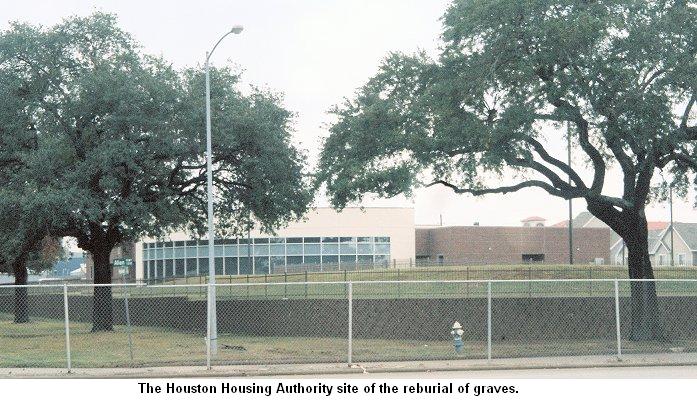
During renovation of Allen Parkway Village in 1996, a number of unmarked graves were uncovered under the playground and buildings along Gillette Street. These graves were in addition to ones disturbed during the original excavations on the site. From 1879 until about 1908, the city operated a hospital (a "pest hous
 e" for
victims of pestilence and disease) and a cemetery in this area which
served the freed slaves and indigent whites residing in Freedmenstown
and the surrounding area. In 1941-1942, during the construction
of the San Felipe Courts (which is now called Allen Parkway Village),
the remains of 928 persons who had been buried in the pauper's cemetery
were removed to Brookside Memorial Park. Obviously, a significant
number of burials in the former city cemetery were missed. To date, an
additional 430 graves have been uncovered during redevelopment of Allen
Parkway Village. The playground at the corner of Gillette Street and
Allen Parkway is closed until further investigations can be done.
e" for
victims of pestilence and disease) and a cemetery in this area which
served the freed slaves and indigent whites residing in Freedmenstown
and the surrounding area. In 1941-1942, during the construction
of the San Felipe Courts (which is now called Allen Parkway Village),
the remains of 928 persons who had been buried in the pauper's cemetery
were removed to Brookside Memorial Park. Obviously, a significant
number of burials in the former city cemetery were missed. To date, an
additional 430 graves have been uncovered during redevelopment of Allen
Parkway Village. The playground at the corner of Gillette Street and
Allen Parkway is closed until further investigations can be done.The remains from the recently discovered graves were reinterred in the land along Heiner Street which the city condemned for $10 and which the City of Houston Housing Authority maintains. The fenced area adjacent to the Housing Authority building contains the numbered, but anonymous, graves of those who have been given a final resting place on this historic spot.
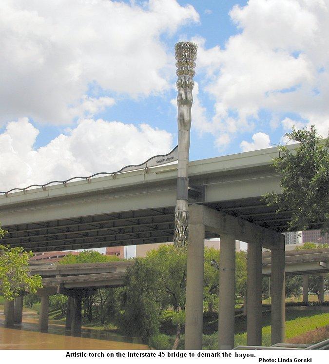
The Interstate 45 bridge over Buffalo Bayou was renovated in 2000. To highlight the presence of Buffalo Bayou, four "bayou beacons" were installed on the bridge to mark the site of the bayou. The thirty foot ornamental steel light towers are designed by local architect Rey de la Reza and sculptor Paul Kittelson. These markers may help us to recognize the bayou waters below the freeway, but also the effects on the community that the freeway has had and the stories of the people who lived in this part of Houston.