Buffalo Bayou
An Echo of Houston's Wilderness Beginnings
  
El Barrio del Alacrán
by
Louis F. Aulbach 

Click for a larger image.
Alacran
The City of Houston experienced an influx of population during the first half of the twentieth century in response to the overall growth of its business and industrial development. Many of its new citizens were Texans of Mexican heritage or Mexican immigrants. They found work in local factories and the ship channel industries.

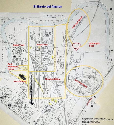
These new residents moved into areas where other Hispanics had already settled and where their Mexican culture was familiar. One of these areas was a part of the Second Ward that had been known generally as Frost Town during the nineteenth century. It encompassed the Frost Town Subdivision, the Moody Addition and Schrimpf's Field. By the early twentieth century, the area consisted of small, run-down homes that were poorly serviced by city utilities. The rents, however, were modest and affordable. During the 1930's and 1940's, this area became known as El Barrio del Alacrán, the neighborhood of the scorpion. It was one of Houston's most notorious slums.

As a community, the Alacrán reflected patterns of other immigrant groups -- gain a foothold in the larger society, adapt and prosper, and assimilate into the mainstream. This process was not always easy. Schools were below par. In the Alacrán, juvenile delinquency was so prevalent that special social programs had to be developed to address the issue. The Rusk Settlement House and, later, the Neighborhood Centers were leaders in this effort.

In the early 1950's, the Alacrán was demolished and replaced by the Clayton Homes public housing project.  As well, the Elysian Viaduct and US Highway 59 were constructed through the area. However, the generation that emerged from the Alacrán produced successful members of the community, business men and women, and community leaders. By the 1960's, the Mexican American community was prepared for the challenge of the civil rights movement for Hispanic citizens that would take place in the 1960's and 1970's.


After the founding of Houston by the Allen brothers in 1836, the  town grew quickly. Houston experienced a sustained growth in population throughout the nineteenth century, and by 1900, the vast majority of the residents of Houston were of either Anglo-American, European, or African-American heritage. Few Houston residents were of Mexican heritage. The census records from 1850 to 1880 indicate that fewer than twenty individuals with Spanish surnames lived in Houston during that thirty-year period. By 1900, when the population of Houston was 44,6331, only about five hundred people of Mexican origin lived in Houston2.

The economy of Houston expanded rapidly in the first decade of the twentieth century, with the growth of the railroads, the emergence of the petroleum industry and the expansion of the ship channel. Jobs attracted many Mexican Texans and Mexican immigrants to Houston – as did the social and political conditions in Mexico resulting from the dictatorship of President Porfirio Diaz and the Revolution. By 1910, there were about two thousand Mexican residents in the city3. These new residents settled around the margins of the downtown district where they could find jobs and cheap housing. As the Mexicans began to settle permanently in Houston's Second Ward, El Segundo Barrio soon became the unofficial hub of their cultural and social life4.


Mexican workers and their families moved into an area of the Second Ward that for most of the nineteenth century was a modest, well-kept neighborhood settled by German and Irish immigrants, known generally as Frost Town. At the end of the century, as the Frost Town neighborhood declined, it was settled by recent immigrants from Eastern Europe and by poor African-Americans, many of whom had migrated to the city from rural areas. By the 1920's, many of the Mexican immigrants lived in the well-worn houses of Frost Town and the adjacent Schrimpf Alley. By then, the residents had another name for their neighborhood, El Barrio del Alacrán (or, simply, the Alacrán).

The Alacrán encompassed an area east of downtown that was bounded on three sides (west, north and east) by Buffalo Bayou. The southern boundary extended along Maple Street and Runnels Street from Crawford Street to the International and Great Northern Railroad tracks, just west of Jensen Drive. This area included five historic tracts of land that date from the earliest years of Houston, namely, the Frost Town Subdivision, the Moody Addition, Schrimpf's Field, the Gabel tract and the Floeck tract5.


In 1907, the free kindergarten sponsored by the Women's Club of Houston moved into the old Floeck/Settegast home6. In 1909, the Houston Settlement Association took over the kindergarten and established their operations in the former Settegast house on Maple Street. The facility was named the Rusk Settlement House because of the kindergarten's affiliation with the Rusk School7. After the Rusk School burned in December, 1910, the City bought the Settegast property as a location for a new school. The Rusk Settlement House was then moved to the back of the lot on Gable Street, and a modern, reinforced concrete and brick Rusk School opened on April 23, 1913. The Rusk Settlement House provided a range of social services to the Mexican immigrants who came to the City to work in the expanding industries along the ship channel. The Second Ward became the center of the Mexican community, and the Rusk Elementary School, the primary educational institution for the Second Ward children, soon became known as the “Mexican School”8.


The demographic changes in Houston's Frost Town subdivision at the end of the nineteenth century and the first decades of the twentieth century are typical of the changes in each of the Alacrán tracts. The pleasant residential housing deteriorated over time and the encroachment of industrial facilities accelerated the decline of the neighborhood.


The homes of Frost Town in the mid-1800's were small, mostly clapboard houses, with flowering shrubs, gardens and cows, goats and chickens. The gable-roofed cottages conveyed an elegance in their simplicity. Although the streets of Frost Town were narrow, like alleys, and covered with boards or wooden planks, Frost Town, as a neighborhood, offered a convenient blend of a rural homestead in an urban environment9. However, by 1890, those simple wood frame houses or log construction residences were described as a “dreary huddle of shabby houses10.” Similarly, the shacks in the adjacent Schrimpf Alley were condemned by the City in 190211.


As German and Irish families prospered and moved to more affluent neighborhoods developing on the city's perimeter to the south and southwest, they were replaced by newcomers who were a lower level on the social and economic scale. Recent immigrants and lower-income African-Americans took advantage of the inexpensive housing in Frost Town, and by 1900, the once predominantly white subdivision had become racially mixed. The racial distribution of the 143 families and single adults was 55.9 percent African-American, and 44.1 percent white.  None were Mexican12.


By 1910, of the 180 families and single adults living in Frost Town, 78.3 percent were African-American, 17.8 percent were white and 3.9 percent were Mexican13. Houston was in the upturn of an economic cycle as the 1920's began. Industrial development was spurred by the opening of the Ship Channel and its associated industries, by the rise of railroad transportation and by the advent of the oil industry. Workers for these businesses came to town and many of them found housing in Frost Town. The population of the Frost Town Subdivision rose to 259 families and single adults at this time. The ethnic make up of Frost Town reflected the rise in the immigration of Mexicans to Houston as the population distribution in Frost Town in 1920 was 49.4 percent African-American, 20.1 percent white and 30.5 percent Mexican14. By 1930, the distribution of families and single adults in the Frost Town Subdivision was 65.8 percent African-American, 10 percent white and 24.2 percent Mexican15.


The ownership of the residential property in the Alacrán was mostly in the hands of absentee landlords who operated rental properties. A few individual resident landowners did exist within the Frost Town Subdivision, however, such as Lorenzo W. Allen on Spruce Street. The Settegast family owned the entirety of Schrimpf's Field in addition to several lots in Frost Town. Other landlords in Frost Town included Jacob Gaber, L. K. Zapp and Isaac Kapner16.


The residents of the Alacrán lived in substandard housing, even in comparison to the standards of Houston housing of that period. The narrow streets and alleys were unpaved and, when it rained, they were muddy and puddle-filled. Few houses had electricity or indoor plumbing. Toilets were usually outside and detached from the house, and they lacked sanitary sewer lines. Trenched channels drained kitchen water away from the homes and down to the bayou. Gas utility service was non-existent and garbage was disposed of by dumping in the bayou ravines. When the wind blew from the east, a cloud of black smoke from the Myers-Spalti furniture factory along the I&GN Railroad tracks hung over the neighborhood17.


The Alacrán was a mix of residential housing and industrial sites. It was increasingly isolated as a residential community because of business and industrial development in the surrounding area. The Houston Light and Power Company plant on Gable Street expanded to the north side of the GH&H railroad tracks for the construction of its cooling tower. The north half of the Moody Square One became the Humble Oil and Refining Company Warehouse and Pipe Yard18.


Further adding to the deterioration of the neighborhood was the Hartwell Iron Works. Hartwell's was established on the south half of Moody Square Number One some time after 1896. By 1903, it was in operation and provided architectural iron work for many of the City's buildings. Fire destroyed the plant some time prior to 1951 and the dilapidated ruins lay in the middle of the neighborhood, enclosed by a six-foot wire fence19. 


Within the southernmost Moody Addition blocks, the construction of the Missouri Kansas and Texas Railroad Freight Terminal and the adjacent Builders Supply Warehouses in 1926 eliminated thirteen houses in Frost Town Block D. The Arthur Steves Lumber Company, on the east side of Gable Street, was situated on the west half of Block A, the closed Arch Street and part of Block B. The Alice Emerson Meat Market was next door to the lumber company on McKee Street and occupied a large part of the west half of Block B. By 1951, five homes in Block E were lost to an auto repair business with a parking lot at the corner of Rains Street and Lyle Street20.


As a result of these industrial developments, the Alacrán was confined to three distinct residential clusters, the Frost Town blocks, the Schrimpf Street houses and the Schrimpf Alley houses. Among these three, there were distinctions in the accommodations that were reflected in the rental rates. Monthly rents for houses or apartments in the Frost Town blocks ranged from $8.00 per month to as high as $50.00 per month for a few of the nicer houses. With larger lots and two-story clapboard houses and bungalows from the nineteenth century, the Frost Town houses had vestiges of its former middle class status.  The majority of the houses, however, rented for $8.00 to $12.00 per month21. Rents for the houses along Schrimpf Street were $10.00 and $11.00 a month. Schrimpf Street sloped crookedly down to the bayou between an oil company warehouse and the Missouri-Pacific Railroad tracks. All of the houses faced west and were patched and mended. Most of them had no inside utilities22. In Schrimpf Alley, the rents were either $8.00 or $10.00 per month for a three room shanty, with an exterior of patched up siding or imitation brick asbestos, that came without lights, gas or running water23. The higher rental rate was charged for houses with a water toilet. On one side of Schrimpf Alley, there were outside sanitary toilets for every four families. Their rent was $2.50 per week. On the other side, the houses had only "outside box privies" and rent was $2.00 per week, but residents had to pay a dollar each time the privy was cleaned, usually twice a month24.


Daily life in the Alacrán was an accommodation to these conditions. Although there was some unemployment, nearly every head of household and most of the older sons had jobs.  They were employed as  shoe makers, biscuit company laborers, biscuit company bakers, compress laborers, cafe cooks, printer contractors, livery stable laborers, hotel bakers, street construction laborers, cotton compress laborers, railroad machinist helpers, and plumbing contractor laborers25. In many homes, the woman of the house cooked on a coal oil stove under light provided by a kerosene lamp. Children filled big buckets of water at  hydrants in the front yard  and lugged them inside cooking and washing. The back yards were a jumble of privies, debris and broken fences where washed clothes were hung alongside the privies26. The local newspaper editorialized that the domestic scene was typical of the scene on rural farms at the end of the nineteenth century, yet even farms in the mid-twentieth century had electric appliances27.


It is not certain when this neighborhood of small, unpainted, ramshackle wooden houses and unpaved streets began to be called El Alacrán. Jesse Coy Vara wrote on his map of the barrio that it existed from about 1934 through 1942, but that may have only been the time of his youth when he lived there28. Schrimpf Street, the single lane, dirt road that ran through the center of the Alacrán and separated the Frost Town blocks from Schrimpf Alley, was called Calle Alacrán by Mexican residents. It was called scorpion street because it was infested with big scorpions (alacranes). The scorpions were so bad in the restrooms that the parents were afraid to let their children go to the restrooms alone29.


The Alacrán moniker appears to be a variation from the “shrimp” of Schrimpf Street which made a long arching curve away from Frost Town toward Buffalo Bayou along the path of the Galveston, Colorado and Santa Fe Railroad tracks. The transformation of the image from curling tail of the benign shrimp to the more sinister image of the scorpion may reflect the frustration and dissidence of some elements of the community. Youth gangs and violence were an indication of the cultural deterioration in the colonia. The Alacrán gang was notorious during the 1940's for its violence.  Members tattooed scorpions on their arms30.


Within the barrio, the neighborhoods were like families. Close ties, reciprocity and frequent socialization were characteristic of life in the Mexican community. There was an immigrant network which developed the practice of sequentially resettling extended families31. In the Alacrán, a close knit group of Mexican families lived where the neighborhood was equally mixed between Mexican and black families. At this time, many children played, went to school and grew up in the shadow of the downtown business center while the fathers worked to support the families and the mothers managed the meager resources and simple furnishings of the homes. In many ways, growing up in Alacrán during the 1940's was an experience like most children have, according to Luz Coy Vara. With many other kids in the neighborhood, they found places to play and things to do. Following the alley behind the Alice Emerson Meat Market and the Arthur Steves Lumber Company to the McKee Street bridge, the children had fun playing on the banks of the bayou, doing the things kids like to do, fishing, swimming and just playing around. They could meet up with the other kids who lived along the alley and make their way to the new McKee Street bridge which captured the imagination and fascination of the young kids32. Although they felt segregated -- the Mexicans stayed to their area, the African-Americans to theirs, and the Anglos to theirs -- their whole life seemed to revolve around the three or four blocks of their neighborhood.  They played baseball in alleys and football on esplanade of Navigation Boulevard, and they generally had a good time33.


Although the families in the Alacrán lived near poverty, there was assistance available to them in their plight. Churches and religious organizations offered help to the Mexican immigrants of the Second Ward. The Rusk Settlement House and the Rusk School provided social services to the community and educational opportunities to the children. Both of these facilities were located within the community on the former Floeck tract in the southwest corner of the neighborhood. The Rusk Settlement House provided lunch time meals, often the best meal of the day for the young children, day care and after school programs. The adults received educational assistance, social services, and language classes to aid in their Americanization34.


Public education was an important part of the assimilation process for the immigrant children. The Rusk School was only a few blocks from the homes in the Alacrán and it was easily accessible by the Mexican children in the surrounding area. The Rusk School on Maple Street was the "Mexican school" for El Segundo Barrio. Although the local school district's policies only addressed the segregation of Caucasians and African Americans, the ethnic make up of the neighborhood resulted in a school that was attended solely by Mexican American children. The curriculum at the Rusk School centered on a variety of vocational skills, and the cooking program was exceptionally good, according to Luz Coy Vara35. The elementary school program, however, had its deficiencies. Staffed with inexperienced teachers, the immigrant children, often with language issues, could not progress quickly. The youthful teachers transferred to more desirable schools when the opportunity came, and the high turnover in teachers was not encouraging for the students at Rusk. It almost seemed as if there were unwritten rules for the students that discouraged promotion into the junior high schools. Kids dropped out of school after a year or two in middle school, and the drop out rate after the eighth grade was very high36.


The poverty and failed educational programs for the local youth enhanced the formation of gangs in the barrios. The Alacrán, in particular, had a reputation for crime and misery. Marijuana use, violence and numerous types of vice were common in the barrio, and juvenile deliquency became a problem in the Mexican community37. The gangs that found expression in zoot-suiterism and pachuquismo. Pachuco gang members carried razors, blackjacks, daggers and other weapons. They prowled the barrio under names such as the Canal Street Gang, the IGN Gang and the Scorpions (Alacranes) which related to their turf in the Second Ward38.


There was a certain ambivalence toward the pachucos among members of the Mexican community. Pachucos wore their hair in long, Vaseline-laced ducktails, they tattooed crosses on their hands, and they dressed in baggy slacks and double-soled, shellacked shoes. To some, the pachucos were merely working class youths displaying a rebellious lifestyle with a distinctive way of speaking, acting and dressing. But to others -- middle class Mexicans and "respectable" working class families – they were abhorrent. This phenomenon reflected a diversity in the Mexican community and a differentiation within the community along sociocultural lines. The assimilation of Mexican immigrants into the Mexican American mainstream was taking two different routes during this time39.


This so-called cultural divide in the Mexican community was demonstrated in the music of choice by the respective groups. "Respectable" Mexicans, that is, those of the middle class and certain working class families, frequented the fine clubs of the colonia, such as Mexico Bello and El Club Recreativo International, where the preferred music was orquestra music. Salones and dance halls helped people escape from harsh realities of life. Patrons packed the establishments of the colonia such as El Salon Juarez, Bonita Gardens Dance Hall, Club Recreativo Tenochtitlan and El Salon Hidalgo. Pachucos, who emerged from the working classes of the barrio, preferred conjunto music over orquestra music. Conjunto was a polka style music that had a large following among laborers and the lower classes of the community. The music of popular conjunto musicians, such as Valerio Longoria and Tony de la Rosa, was played in cantinas, rather than the fine clubs.  There was one cantina in the Alacrán, located on McKee Street. If music were played in that place, it would have been conjunto40.


By the early 1940's, juvenile delinquency in the Mexican community had become a serious problem. The trial of juvenile gang members for killing a gang member's father in Magnolia Park was sensationalized in the local newspapers, and the general population of Houston became alarmed at the rise in juvenile delinquency. The problem was recognized as something more than just a problem in the Mexican community41. The Houston Settlement Association had for many years promoted the programs of the Rusk Settlement House as an antidote to juvenile dilenquency and youth gangs. However, budget shortfalls during the Depression at the Houston Community Chest, Rusk's funding agency, curtailed many of those programs42.


In 1943, the Ripley House partnered with the Houston Settlement Association to keep the Rusk Settlement House operating, and it hired Franklin I. Harbach, an experienced social worker from New York City, to be its new director43. Harbach forged alliances with Houston's philanthropic groups and the leaders of the Mexican American community in order to address the social aspects of delinquency in the barrio. The city built new playgrounds, installed street lights and provided more police presence in the Second Ward44. Harbach himself often acted as an intermediary between the youth gangs and police. He also joined forces with Roy Hofhienz, the Harris County juvenile court judge, to assist in the reform of the juvenile justice system. With Harbach's encouragement, the Mexican American community itself initiated ways to rehabilitate the barrio youths and implement reforms45. Felix Tijerina, a local prominent businessman and immigrant, founded the Good Citizen League which organized sports leagues and built baseball fields to give youths an alternative to crime. The League sought to persuade youths to stay in school and become better citizens46. The baseball field in the Alacrán was located at the end of Race Street, on the east side of the GC&SF railroad tracks. Games at that field were fondly remembered by youths who played there, even decades later47.


In addition to these local efforts to improve the outlook for Mexican Americans in the community, the national situation during World War II also presented opportunities for the young men in the barrio. Many of them joined the military services and served around the world during the wartime. Service in the military broadened their experiences and helped to transform their identity from temporary immigrant to permanent American of Mexican descent. Many took advantage of the GI Bill after the war to improve their education, as well48.


In the prosperity that followed the end of World War II, Houston grappled with the issues of the Alacrán. Newspaper columnist Sigman Byrd declared the blocks of Frost Town to be one of Houston's worst slums49. A similar description was applied to the houses of Schrimpf Alley50. The blight was too blatant to ignore, and the city proposed to tap into money for a housing project that was originally set aside in 1940 by the Public Housing Administration, but was delayed by the war51. William L. and Susan V. Clayton, Houston philanthropists, were interested in housing projects as a means of slum clearance, and they bought twenty-three acres of Schrimpf's Field from the heirs of the Settegast Estate for the urban renewal housing project. On January 4, 1951, Susan V. Clayton donated the land to the Houston Housing Authority for a 348 unit slum clearance project costing $2,295,000 that would provide low cost housing for Mexican residents52.


With much media coverage, on Tuesday July 3, 1931, the family of Francisco Banda, a junk dealer and Full Gospel minister, his wife Carmen, and their three children wase the first moved out of their home on Schrimpf Alley by the housing authority. Although the housing authority truck only moved the Banda family to a temporary home on the other side of Schrimpf Alley, it was a symbolic gesture that signaled the end of the notorious slum. Throughout the month of July, families were moved from the site, and bulldozers rammed the dilapidated houses and knocked them down. The rubble was then pushed down to the banks of Buffalo Bayou and set fire53. In March, 1952, the new housing project was turned over to the Houston Housing Authority and dedicated as the Susan V. Clayton Homes54.


The post-World War II economic boom led civic planners to envision automotive links across Buffalo Bayou from the northeast side of town. Elysian Street was to be connected by an elevated roadway through Frost Town to Crawford Street, and U. S. Highway 59 was to be constructed over Schrimpf's Field and joined with the new highway route east of Jensen Drive on the north side of the bayou. The Elysian Viaduct, a joint project of the City of Houston, Harris County and the State of Texas, was built in 195455. The remaining one third of Schrimpf's Field was purchased by the state in the mid-1950's for the construction of US 5956. These highway projects complemented the Clayton Homes urban renewal project and brought about the end of the ramshackle houses on Schrimpf Street and the demise of Frost Town as a residential neighborhood. The Alacrán ceased to exist.


The story of the Alacrán is the story of the first large wave of Mexican immigration to Houston. It is the story of their personal quest for integration into mainstream society and as well as the story of the efforts of the mainstream society of Houston to assist in that process. The generation of Mexican Americans that came out of the Alacrán and the other barrios of Houston were prepared to address the issues of civil rights that would come in the 1960's and 1970's. The census of 2010 found that over 673,000 Mexican Americans live in Houston. They comprise 32.1 percent of the city's population57 and are well represented in the local government, the business community and the social organizations of Houston.


HISTORICAL AND CULTURAL SIGNIFICANCE

During the first decades of the twentieth century, Houston attracted a large number of Mexicans to the downtown's Second Ward where the old neighborhood of Frost Town and adjacent areas offered inexpensive, but often dilapidated housing with few services or utilities. As more Mexicans settled in the area, the community, called El Segundo Barrio, provided the immigrants with a foothold in their new country.


Two neighborhood institutions assisted the assimilation of the immigrants into the mainstream society. The Rusk Settlement House, originally formed to help an earlier wave of immigrants from Europe, adapted their programs for the Mexican immigrants, and the Rusk School provided elementary public education for their children.


During the Depression, the impoverished conditions in the barrio made it difficult for the Mexican population to thrive, and the rise of youth gangs in the neighborhood brought crime and juvenile delinquency to barrio life. A new name for the barrio reflected this change in character of the neighborhood which became El Barrio del Alacrán, the neighborhood of the scorpion.


During the 1940's, the Houston Settlement Association reinvigorated its social programs to counteract the rise of juvenile delinquency in the Alacrán. Franklin Harbach, director of the Rusk Settlement House, built alliances with the county juvenile court judge and local Mexican business leaders to address the problems of the youth in the barrio. With some success, the juvenile justice system was reformed and community involvement in the barrio gave youth positive alternatives to gang participation. In the early 1950's, the Houston Housing Authority built the Clayton Homes on a part of the slum known as Schrimpf Alley to remove the blight of urban decay in the Alacran. The construction of the Elysian Viaduct and U. S. Highway 59 demolished the remaining slum areas of the Alacrán.


The story of the Alacrán represents the personal quest of Mexican immigrants for integration into the mainstream. The generation of Mexican Americans that came out of the Alacrán was prepared for the civil rights struggles of the 1960's and 1970's. Today, Mexican Americans are well represented in the local government, the business community and the social organizations of Houston.


1 "Houston." Wikipedia. <http://en.wikipedia.org/wiki/Houston> [Accessed June 24, 2012].

2 Roberto R. Trevino. The Church in the Barrio: Mexican-American Ethno-Catholicism in Houston (Chapel Hill, NC: University of North Carolina Press, 2006), p. 25-26.

3 Ibid., p. 26.

4 Jesus Jesse Esparza. "La Colonia Mexicana: a history of Mexican Americans in Houston." Houston History, Volume 9, Number 1 (Fall 2011), p. 2.

5 Louis F. Aulbach. Buffalo Bayou: an echo of Houston's wilderness beginnings (Houston: Louis F. Aulbach Publisher, 2012), p. 385-400, 408-462, 465-476.

6 "School Histories: the stories behind the names." HISD. <https://www.houstonisd.org/HISDConnectDS/v/index.jsp?> [Accessed March 4, 2011].

    "Houston, 1907. Volume 1, Sheet 10." Sanborn maps, 1867-1970: Texas.

    Betty T. Chapman. "Settlement houses: Havens of help in early Houston." Houston Business Journal, December 29, 2000-January 4, 2001.

7 Ibid.

    Betty Martin. "Neighborhood Centers boosting people's lives." Houston Chronicle, Thursday, 08/18/2005. Section: This Week, Z11, Page 1, 2 Star Edition.

    "Settlement House Opened." Galveston Daily News, May 5, 1909, page 9.

8 "Summary of news." Galveston Daily News, December 16, 1910, page 1.

    Gunter, Jewel Boone Hamilton. Committed, the official 100-year history of the Woman's Club of Houston, 1893-1993 (Houston: D. Armstrong, Inc., c1995).

    "New Rusk School opens." Galveston Daily News, April 23, 1913, page 3.

    "Houston, 1924. Volume 1, Sheet 29." Sanborn maps, 1867-1970: Texas.

    "Mexicans in Houston Today." Houston History. <http://www.houstonhistory.com/> [Accessed January 25, 2005].

    Betty T. Chapman. "Settlement house in Second Ward relieved problems of overcrowding." Houston Business Journal, March 14-20, 1997.

9 Sr. Fannie Mae Mead [sic: Wead]. "Frost Town." Genealogical Record, June 1984. Pages 64-67.

10 "Historic Frost Town." Art & Environmental Architecture, Inc. <http://www.frosttownhistoricsite.org/> [Accessed January 10, 2003].

11 Bud Bigelow, photographer. "Schrimpf Alley goes smash." Houston Post, July 6, 1951.

12 Analysis of the 1900 United States Census data for the Frost Town blocks by the author.

13 Analysis of the 1910 United States Census data for the Frost Town blocks by the author.

14 Analysis of the 1920 United States Census data for the Frost Town blocks by the author.

15 Analysis of the 1930 United States Census data for the Frost Town blocks by the author.

16 Gladys Clark. Files, 1986. "Frostown-Moody Ownership Map, 1946." A copy is in the author's possession.

17 William Sebastian Bush. Representing the Juvenile Delinquent: Reform, Social Science, and Teenage Troubles in Postwar Texas. Ph.D. Dissertation. University of Texas at Austin, 2004, p. 90.

    Eddie Krell. "They dream of new homes today in Schrimpf Alley." Houston Chronicle, Thursday, January 4, 1951. Page 2.

    "Clayton Housing Slated." Houston Chronicle, January 4, 1951. Page 1.

    Sigman Byrd. "In the Undecked Halls of Houston's Schrimpf Alley." Houston Press, 12-22-1950, page 15.

18 "Houston, 1924-1951. Volume 1, Sheets 25, 26." Sanborn maps, 1867-1970: Texas.

19 "Houston, 1924-1951. Volume 1, Sheet 26." Sanborn maps, 1867-1970: Texas.

    "First Ward." Historic Neighborhoods Council. March 2005. Greater Houston Preservation Alliance.

20 "Houston, 1924-1951. Volume 1, Sheets 25, 26." Sanborn maps, 1867-1970: Texas.

21 "Houston, 1924-1951. Volume 1, Sheet 26." Sanborn maps, 1867-1970: Texas.

    "1930 United States Census, Series T626, Roll 2346, Page 122." Heritage Quest Online.

22 Sigman Byrd. "The Street of the Scorpion, Where Death Hath No Sting." Houston Press, Wednesday, February 14, 1951, page 15.

23 Byrd, "In the Undecked Halls of Houston's Schrimpf Alley," 1950.

24 Krell, 1951.

25 1930 United States Census data for Frost Town blocks.

26 "Clayton Housing Slated." Houston Chronicle, January 4, 1951. Page 1.

    Sigman Byrd. "In the Undecked Halls of Houston's Schrimpf Alley," 1950.

    Krell, 1951.

27 "Our City - City vs Farm." Houston Chronicle, January 6, 1951.

28 Luz Coy Vara. "A hand drawn map of El Barrio del Alacrán by Jesse Coy Vara, 2004." A copy is in the author's possession.

29 Sigman Byrd. "The Street of the Scorpion, Where Death Hath No Sting," 1951.

30 F. Arturo Rosales. "Mexicans in Houston: The struggle to survive, 1908-1975." Houston Review. Volume 3, No. 2 (Summer 1981), (Houston: Houston Library Board, 1981), p. 224-248.

31 Roberto R. Trevino. The Church in the Barrio: Mexican-American Ethno-Catholicism in Houston (Chapel Hill, NC: University of North Carolina Press, 2006), p. 30.

32 Luz Coy Vara. Personal communication. October 10, 2004.

33 Félix Fraga, 1929-. Houston Oral History Project, September 14, 2007. Houston Public Library. (http://digital.houstonlibrary.org/oral-history/felix-fraga.php , Accessed June 18, 2012). Felix Fraga, a former City Council Member and a Vice President of the Neighborhood Centers, is probably the most notable person to have come out of the Alacrán. Although the Fraga family lived on McAlpine Street, about four blocks from the Alacrán, Fraga attended the programs of the Rusk Settlement House as a child and played youth baseball at the ball field in Schrimpf's Field.

34 Ibid.

    Arnoldo De Leon. Ethnicity in the Sunbelt: Mexican Americans in Houston (College Station: Texas A & M University Press, 2001), p. 27-28.

35 Vara, Personal communication, 2004.

36 De Leon, p. 27.

    Fraga, 2007.

37 Ibid.

    De Leon, p.56.

38 De Leon, p.105, 108.

39 Manuel Pena. The Texas-Mexican Conjunto: History of a working-class music (Austin: University of Texas Press, 1985), p. 140, 143.

40 Ibid.

    Thomas A. Krenek. Mexican American Odyssey: Felix Tijerina, Entrepreneur and Civic Leader (College Station: Texas A&M University Press, 2001), p. 64-65.

    Jesus Jesse Esparza. "La Colonia Mexicana: a history of Mexican Americans in Houston." Houston History, Volume 9, Number 1 (Fall 2011), page 4.

41 De Leon, p. 105-106.

42 Bush, 2004, p. 90.

    William S. Bush. Who gets a childhood?: Race and juvenile justice in twentieth-century Texas (Athens, GA: University of Georgia Press, 2010), p. 47-48.

43 Thomas McWhorter. "Trailblazers in Houston's East End: The Impact of Ripley House and the Settlement Association on Houston's Hispanic Population." Houston History, Volume 9, Number 1 (Fall 2011), p. 11-12.

44 Bush, 2010, p. 53.

45 Ibid., p. 48.

46 De Leon, p. 109.

47 Vara, "A hand drawn map of El Barrio del Alacrán by Jesse Coy Vara, 2004."

    Fraga, 2007.

    Frank Fraga, personal communication, May 22, 2010.

48 Esparza, p. 4-5.

    Fraga, 2007.

49 Sigman Byrd. "'The Houston Story': Notes on a bookman and his book." Houston Press, 04/12/1951.

50 "Houston, 1924-1951. Volume 1, Sheet 28." Sanborn maps, 1867-1970: Texas.

    Kirk Farris. Personal communication. August 17, 2003.

51 "Schrimpf Alley slums fade." Houston Chronicle, August 5, 1951.

52 "Mrs. Clayton aids in cleaning up of Houston slum area." Big Spring Daily Herald, January 4, 1951, page 3.

53 "Clearance week for new 348-unit housing project begins today." Houston Post, July 5, 1951.

    Larry Evans, photographer. "First Schrimpf Alley Family." Houston Chronicle, July 4, 1951.

    Bigelow, 1951.

54 De Leon, p. 101.

55 "Who we are." Preservation Texas. <http://www.preservationtexas.org/about/index.htm> [Accessed August 29, 2005].

56 "Public Housing Debate: Houston's public housing fight of the 1940's - 50's." Texas Housing. Texas Low Income Housing Information Service. <http://www.texashousing.org/txlihis/phdebate/past 113.htm> [Accessed August 7, 2001].

    Mike Snyder. "Public housing, private hopes / City planners look to project as a catalyst." Houston Chronicle, Sunday, 10/25/1998. Section: A, Page 33, 2 Star Edition.

    "US 59 proposed route across Buffalo Bayou, 1955." Texas Freeways. <http://www.texasfreeway.com/Houston/historic/road_maps/images/> [Accessed August 29, 2005].

57 "Profile of General Population and Housing Characteristics: 2010 Demographic Profile Data. Houston, TX." American Fact Finder. U. S. Census Bureau. <factfinder2.census.gov/faces/tableservices/jsf/pages/productview.xhtml?src=bkmk> [Accessed August 5, 2012].


  All material printed on this page and this web site is copyrighted. All rights reserved.

Copyright by Louis F. Aulbach, 2012


Back to Main Page  |Buffalo Bayou  |  Contact | The Lower Canyons  |  The Upper Canyons  |  The Great Unknown  |  The Devil's River  |  The Lower Pecos River